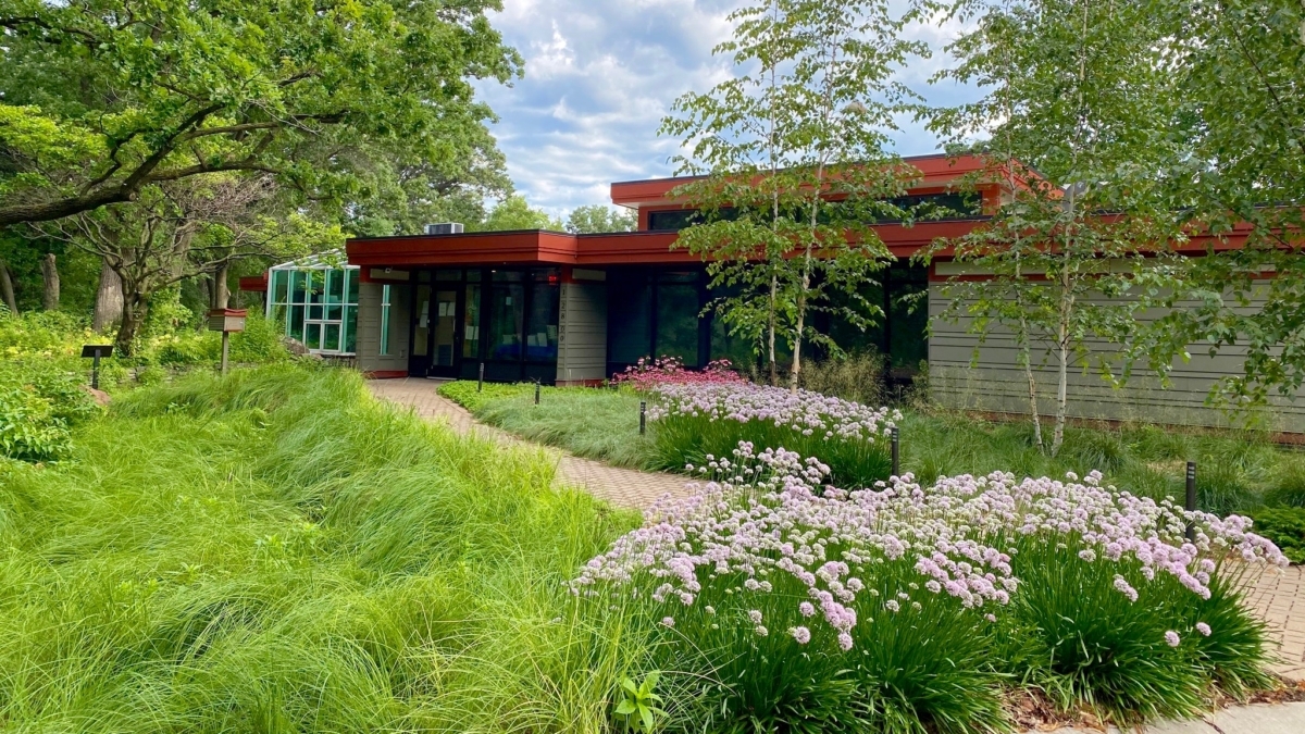
Discovery Point, Nine Mile Creek Watershed District's headquarters in Eden Prairie. Photo by Nine Mile Creek Watershed District
Editor’s note: This 3-part, in-depth feature by Jeff Strate explores how Eden Prairie’s residents, city staff, and watershed leaders are confronting the challenges facing local lakes and streams – from salt runoff to algae blooms. It’s a story of science, stewardship, and community action. This is Part 2.
Nine Mile Creek Watershed District (NMCWD) Administrator Erica Sniegowski and project manager Brett Eidem helped Eden Prairie Local News (EPLN ) reporters Jim Bayer and me come to grips with the causes and cures for contaminated creeks and lakes. We gathered at Discovery Point, the agency’s handsome headquarters and learning center set on five wooded acres above a wetland. You can find Discovery Point at 12800 Gerard Drive.
The watershed district contracts with a variety of professional consultants, including Barr Engineering, to help test, evaluate, plan, budget and execute fixes. The freeways, streets, sidewalks, rooftops, parking lots and lawns in Nine Mile’s nearly 50-square-mile watershed can pollute rain and snowmelt runoff on its way to lakes and the creek.
Nine Mile’s two source branches — one in Minnetonka, the other in Hopkins — converge in northwest Bloomington. The stream then flows into shallow Lake Normandale and curls through wetlands and suburban neighborhoods on its descent to a floodplain and the Minnesota River.
About a decade ago, Nine Mile Creek had the second-highest concentration of chloride seeping into the Minnesota River among tributary streams in Hennepin, Dakota, Scott and Carver counties. And although Nine Mile carried enough sediment per year to fill seventy-nine 15-ton dump trucks, it is among the lowest carriers of sediment in the four counties.
The south branch of Nine Mile Creek flows into Eden Prairie’s Bryant and Smetana lakes. Because of watershed district projects, Bryant has become healthier, and so, too, has shallower Smetana. The agency is currently conducting a water quality study of the Anderson Lakes chain. Community feedback meetings began in August.
‘Extreme Makeover: Stream Edition’
If recent work along a 3,400-foot stretch of the south branch of Nine Mile Creek had been a reality TV episode, it could have been branded “Extreme Makeover: Stream Edition.”
 A few year back, this stretch of Nine Mile Creek’s South Branch was more of a ditch held hostage by tangles of thick buckthorn and weeds. July 12, 2025 photo by Jeff Strate
Eidem explained that contractors narrowed reaches of the creek bed and installed tree trunks, rocks, root wads and brush bundles with plantings of native sedges, bulrush and milkweed along the bank. Rocks were strategically placed in the stream to reduce erosion and improve habitat for minnows, creek chub and dace. A new wetland was created, and other reaches of the creek were reconnected to natural floodplains.
 Restoration work of the South Branch included placement of rocks to create riffles and improve fish habitat. Photo by Jeff Strate
The joint NMCWD-Bryant Lake Regional Park project also cleared 14 upland acres of buckthorn and garlic mustard for plantings of indigenous bur oak, pagoda dogwood, wildflowers, sedges and prairie clover. The payoffs are a healthier creek and time-warped views of Eden Prairie before buckthorn.
The Mitchell file
Last year, volunteers from the Friends of Eden Prairie Parks and the Mitchell Lake Association (MLA) joined city parks staff to clear buckthorn along the lake’s wooded shoreline between the Miller Park playground and the boat ramp. Reintroduction of native plants in the cleared areas began in June.
 Volunteers posed for a “heroes” photo on Sept. 17 after taking care of business in Miller Park. Submitted photo
MLA’s Jim Nehl reports that lakeside residents, the Friends of Eden Prairie Parks and a “great group” from Winnebago Industries are among those planting native Minnesota reinforcements in Miller Park.
Karli Wittner, the city’s parks and natural resources supervisor, said that on Sept. 17, more than 15 volunteers planted 17 native species — totaling 743 individual plants — in just two hours. Among them were sedges, ferns, poke milkweed, Jacob’s ladder, early meadow rue and pollinator-friendly wildflowers. The progress in the park along Mitchell’s shore and nearby woods is supported by Minnesota Department of Natural Resources Conservation Partners Legacy Grant funds.
On Sept. 22, the first day of autumn, 630 wetland plants were carefully set into one of two new rain gardens beside the hard surface of Miller Park’s pickleball courts. Volunteers from Home Depot and the Friends of Eden Prairie Parks helped make it happen. The swales will filter stormwater that otherwise might carry debris to Mitchell Lake.
 Cheri and Jim Nehl, their Mitchell Lake buffer strip, pontoon boat and dock. September 24 photo by Jeff Strate
Jim and Cheri Nehl founded the Mitchell Lake Association 19 years ago this September — the first of its kind in Eden Prairie. The group has partnered with the city, the Riley Purgatory Bluff Creek Watershed District, and residents on projects to rescue the lake from invasive curly-leaf pondweed and milfoil, lawn grass clippings and blue-green algae blooms.
The 124-acre lake charms with its wooded shorelines, bays, coves, peninsulas and 134 homes. Although Mitchell Lake was removed from the Minnesota Pollution Control Agency’s impaired-waters list in 2018, aquatic plant tangles in offshore shallows can be a drag for pontoon boaters, kayakers and anglers.
“The most feedback we get from people living on the lake is what they call ‘the weeds,’” says MLA secretary Cheri Nehl. “We’ve got 15 different aquatic plants on our lake, most of which are native, but the curly-leaf pondweed, and now the milfoil, they’re causing quite a problem.”
Only a small portion of the lake can be treated with herbicides in the spring. Those applications are managed by the Riley Purgatory Bluff Creek Watershed District. Later in the summer, aquatic-weeding boats cut navigation channels. The same happens on Red Rock Lake. “But it’s never enough,” Nehl added.
Down on the river
A year ago this September, Sever and Aaron Peterson were aboard one of the Jonathan Padelford riverboats for a late afternoon cruise organized by the Lower Minnesota River Watershed District (LMRWD).
They were part of a group of scientists, agriculture and water policymakers and administrators, farmers, and sportsmen. The river ramble featured scientific and policy briefs, Q&A sessions, picnic food, live music, and plenty of time for sightseeing from Savage to the Mississippi River and St. Paul. The special cruises began around 2013.
 Photos by Jeff Strate
The Petersons have farmed the river bottomlands south of Flying Cloud Drive at Spring Road for five generations. They are the Petersons of Sever’s Corn Maze and Fall Festival fame.
(A 2021 EPLN article describes these attractions’ Eden Prairie origins.)
As their sidewheeler glided by riverine forests, egrets and a few barges, Aaron Peterson told EPLN that the Minnesota looks as it did when he was a kid, except for more frequent flooding. The sweet corn, soybean, pumpkin and organic hemp farmer thinks that “the agricultural community can incorporate more minimum tillage practices and look at alternatives to sulfate-based fertilizers.”
He also wants more farmers to consider “re-wilding” areas that could hold and absorb heavy rain before it gushes into county ditches and creeks. Aaron has served as a board member of the Friends of the Minnesota Valley, a nonprofit conservation group.
The dramatic 2024 Rapidan Dam washout on the Blue Earth River — a few miles upstream from its confluence with the Minnesota River near Mankato — remains a symptom of climate-related challenges.
“And I get it,” Sever Peterson said. “I’m a farmer. And I understand what drainage does. We’ve got to realize what the drainage is doing downstream and the complications it makes for all of us downstream.”
The watershed of the Minnesota River spans nearly 17,000 square miles and is mostly agricultural. A 13-year U.S. Geological Survey study of the river at Mankato found that a load equal to 2,700 tons of sediment per day — or a 10-ton dump truck load every 5½ minutes — was carried in the current.
Some of it settles in the floodplains and riverbanks of Chaska, Eden Prairie, Bloomington, Savage, Burnsville, and Eagan. When the floods recede, the chemically blended muck shows up.
 Passengers boarded the Anson Northrup sidewheeler from a mud-caked Minnesota River shore at Port Cargill, Savage. September 10, 2024 photos by Jeff Strate
That’s why the Lower Minnesota River Watershed District has taken the lead on many projects within an area that includes rare calcareous fens, trout streams, migratory flyways and farmland, the Minnesota Valley National Wildlife Refuge, creeks, lakes, suburban neighborhoods, an international airport, the Mall of America, landfills, industries, barge channels, and unstable bluffs.
 A project may soon begin to stabilize erosion on a Minnesota River riverbank in southeast Eden Prairie. Photo by Lower Minnesota River Watershed District
“Hopefully we’ll get this project done by the end of the year so I can retire,” said retiring LMRWD Administrator Linda Loomis during a Sept. 2 Eden Prairie City Council meeting. “This has been on the table since before I started with the district in 2013.”
The bluff that swoops down from homes on the western end of Riverview Road has been a city and watershed district headache since 2008. The flow of the Minnesota River into a sharp bend there erodes the toe (bottom) of the bluff about 3 feet each year. Trees, brush, and sandy soil have toppled into the river.
Several studies of the geologically complex area and two attempts to stabilize it near a defunct runoff pond have failed. That may soon change.
 Retiring Lower Minnesota River Watershed District Administrator Linda Loomis addressed the Eden Prairie City Council on September 2. Images from CityTV streaming service
LMRWD has purchased a 4-acre strip along the eroding riverbank. The City Council approved the district’s request for a zoning change on the parcel from rural to parks and open space.
Addressing Mayor Ron Case and council members, Loomis explained, “We felt that the property should be in public ownership for continued maintenance and construction of the project.”
The project would stabilize the riverbank and could begin in November.
Long ranks of large boulders will be placed along 1,100 feet of the toe in the river and up the bank in a way that will allow them to reposition naturally when erosion threatens. River flow and gravity will do the work.
Areas disturbed during construction will be seeded with native plants. The watershed district, city, and state are sharing the $6 million cost of the project. It’s another small, caregiving step toward restoring the health of the Minnesota — and the Mississippi.
More than 63 species of fish live in the Lower Minnesota River, including channel catfish, flathead catfish, and freshwater drum. Only the western third of the river’s meandering course along Eden Prairie’s southern border is listed as impaired.
The river remains fishable upstream, according to a couple of anglers. Pickup trucks with boat trailers and fishing gear often park at the boat ramp below the Highway 101 causeway, just outside Shakopee.
 Activist and educator Judy Berglund is also a member of the Lower Minnesota River Watershed District’s Citizen Advisory Committee. Images from LMRWD video.
River whisperers
In January, Judy Berglund — the Eden Prairie resident who sweeps up street salt mentioned in Part 1 of this series — was one of 15 presenters during a nearly three-hour listening session at the Minnesota Valley National Wildlife Refuge Headquarters and Bloomington Education and Visitor Center. The listeners, a panel of LMRWD managers, heard from experts and river watchers.
One urged the return of discontinued reimbursement programs for farmers to restore wetlands that had been drained for croplands. Using a graphic-rich PowerPoint slideshow, another explained how small gullies grow into large ravines that pollute the river.
Minnesota River Congress coordinator Scott Sparlin, of New Ulm, called for programs to better represent and coordinate the diverse communities within the Minnesota River basin. He quipped, “You guys (in the metro region) are getting all the water. We’re the ones sending it to you.”
Eden Prairie’s Berglund spoke, as an educator, about the power she sees in younger generations who are shaping their own future and caring for our — for their — water resources. The Eden Prairie activist reminded listeners that learning programs can help young and old “to understand what we do has consequences to the environment.”
Next in this series
In Part 3, “Eden Prairie’s water stewards” takes a look at what individuals can do, while providing a review of water stewardship organizations.
Read Part 1, about the definition of impaired waters and City of Eden Prairie road salt and storm drain initiatives,
here.
.series-next {
border-top: 2px solid #ccc;
margin: 2.5rem 0;
padding: 1.5rem 0;
font-family: Georgia, “Times New Roman”, serif;
}
.series-next .kicker {
font: 700 14px/1.6 -apple-system, BlinkMacSystemFont, Segoe UI, Roboto, Helvetica, Arial, sans-serif;
letter-spacing: .05em;
text-transform: uppercase;
color: #555;
margin: 0 0 .5rem;
}
.series-next .series-link {
font-size: 1.25rem;
line-height: 1.6;
color: #111;
}
.series-next .series-inline-link {
color: #111;
text-decoration: none;
}
.series-next .series-inline-link:hover {
text-decoration: underline;
}
@media (min-width:768px) {
.series-next .series-link {
font-size: 1.375rem;
}
}
Editor’s note: Writer Jeff Strate is a founding EPLN board member. EPLN’s Jim Bayer contributed to this series.